

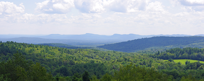
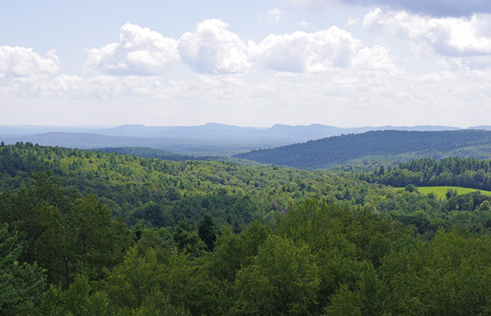
Some 260 acres of patchwork forest and field provide the setting for Smith College’s Ada and Archibald MacLeish Field Station in West Whately, Massachusetts, about 11 miles from the Smith campus. The property supports a beautiful and diverse ecosystem of plants and animals—from towering hemlock trees to spotted salamanders scuttling across the forest floor—and is, of course, abundant with research opportunities. Scientific inquiry flourishes here, and rich stories emerge about the professors and students who spend a summer, a semester, a day, measuring the diameters of massive tree trunks, collecting water samples, planting seedling orchards or researching the recorded history of the land, which spans more than four centuries. And, as most of those familiar with MacLeish assert, there is still much yet to do.


A century and a half ago, one in four trees in the native forests of the American Northeast were thought to be American chestnuts, standing up to 100 feet tall and numbering about four billion, in a range that extended from southern Maine to northern Georgia. Now there are none.


By 1950, the American chestnut was gone, declared “ecologically extinct.” It had been wiped out by a fungal disease known as chestnut blight that accidentally entered the United States in 1904 on imported chestnut trees from China.
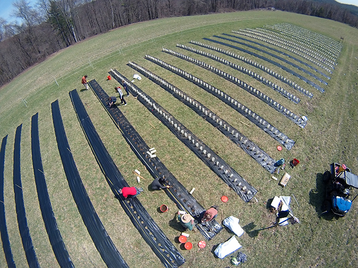
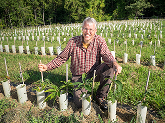
Today, however, some 2,100 hybrid chestnut seedlings thrive in an irrigated, one-acre grove at the MacLeish Field Station, where they are being carefully planted and tended to by Smith conservationist Paul Wetzel and a volunteer team of Smith students. Wetzel is collaborating with The American Chestnut Foundation (TACF) to restore to the eastern United States this lost species of a once-grand North American tree.
Paul Wetzel
Thanks to this carefully orchestrated breeding project, the potentially blight-resistant chestnut seedlings—some 20 different varieties of Chinese-American hybrids—grow here in the MacLeish seed orchard under a formal agreement with TACF, a nonprofit conservation group. Smith College is one of the few colleges in the U.S. working in concert with the foundation to manage seedling orchard plantings as part of the national effort to develop a blight-resistant hybrid. The college has granted the TACF an easement to grow and collect chestnuts in the orchard for 30 years.
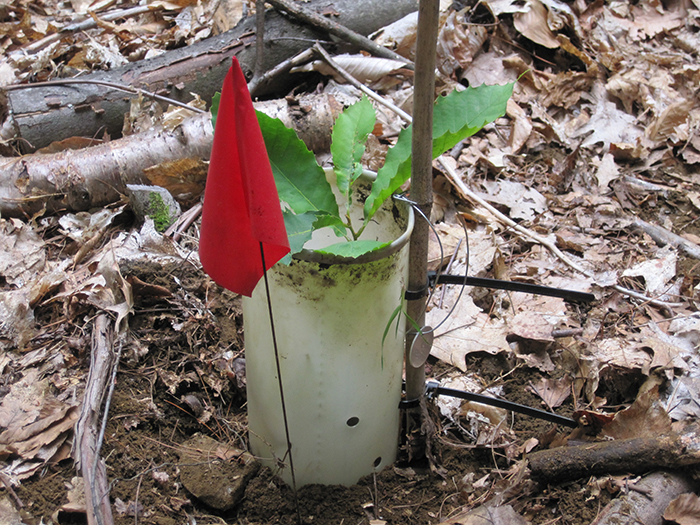
At the same time, Wetzel, who is the environmental research coordinator for the Smith Center for the Environment, Ecological Design and Sustainability, is monitoring another 600 hybrid chestnut nuts planted in a variety of cleared and not-so-cleared forest plots scattered throughout the MacLeish property. By creating different-sized gaps in the forest to allow for light to reach the growing chestnuts, he has designed an experiment to determine how large a gap is necessary for chestnuts to thrive in a canopy forest and become “ecologically functional” again. He checks these forest plantings two times a year, measures the growth of the seedlings and monitors for predators, which are numerous. Many of the seedlings haven’t made it, Wetzel says, because wildlife finds them tasty.
Indeed, farmers once gathered chestnuts to feed to their hogs and cattle. And at MacLeish, the rodents and the deer vie for a chance to devour the savory nut. “When you plant nuts, predation is the first hurdle to overcome. Chestnuts are very tasty, big and sweet to squirrels and chipmunks,” Wetzel notes.
Consequently, the seedlings growing in the one-acre manicured orchard are protected from predators by a solar-powered electric fence. The orchard was established at MacLeish two years ago.
It is a long-term endeavor that calls for meticulous oversight and the commitment of Smith undergraduates interested in working on a prominent conservation project. Working with a team of students, Wetzel plants the orchard seedlings, surrounds the saplings with plastic tubes to protect them from rodents and deer, and then regularly monitors tree growth. Some 20 Smith students have been involved in the project, helping to plant and monitor the fledgling trees.
Eventually 3,000 trees will be planted at MacLeish, Wetzel says, and of those, 20 will be selected to produce seed for the American chestnut reintroduction in the Northeast.
“We’re hoping that from 3,000 seedlings, we will end up with only 20 potentially blight-resistant hybrids,” says Wetzel. “That little grove of 20 chestnut trees will represent six generations of hybrid plantings and crossings.”


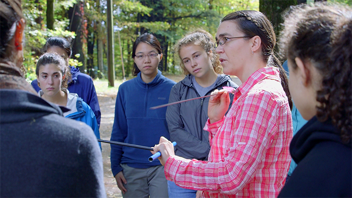
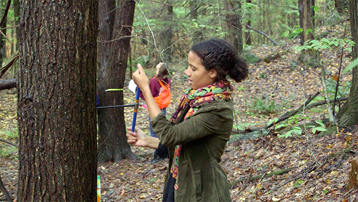
It is a fall afternoon at the MacLeish Field Station and 20 Smith students are gathered around Marney Pratt, biological sciences lab instructor, as she briefs them on their field assignments. Their mission today will involve the trees—many of which are massive and more than 100 years old—in the nearby thickets of oaks, hemlocks, black birches and white pines. Their task: measuring tree trunk diameters and collecting wood samples from the tree cores.
But before they get into the trees, Pratt goes over what’s in the six equipment bags on the ground—one bag for each group of students. Tree corer? Check. Tape measure? Check. Compass? Check. Straws? Check. The straws, by the way, will hold the small, slender pieces of wood that are going to be extracted during the coring process and transported to the lab on the Smith campus. The samples will later be analyzed, recorded and dated.
For the duration of this semester-long Biodiversity, Ecology and Conservation laboratory, students will learn observational and experimental protocols in both the lab and the field. The MacLeish Field Station, 260 acres near Northampton, Massachusetts, offers students opportunities to explore and conduct experiments on plant species and other organisms in their natural habitats—the unsullied patchwork of forests punctuated by rolling meadows, waterways and vernal pools. On this field trip, the measurements and samples collected by the students might not seem significant to the casual observer. But today’s work will yield solid data about the abundance and health of the native eastern hemlock trees, which are beginning to fall prey to the hemlock woolly adelgid, an invasive, aphid-like insect.
This is the cornerstone of an ongoing research project led by Jesse Bellemare, assistant professor of biological sciences.
That the MacLeish forests are being invaded by the woolly adelgid is a given, but what Bellemare’s research brings into focus is how the forests will change in the next 20 years if the hemlocks continue to die and are succeeded by another species such as black birch. Among the questions his research explores are: How will the forest floor change, and how will that affect the salamander population that thrives in the ecosystems provided by the decomposing of hemlock wood debris and leaves of other trees? How will the loss of hemlocks affect how other plant species thrive in the changing soil material?
On this day, Smith students, deep in thickets of trees, scramble across the leaf-strewn forest floor, measuring and coring. There are the sounds of unspooling tape measures, and a tree-boring tool as its handle is turned, knocking against the bark of a tree. Voices. Questions. “What did you find?” “Where’s the compass?” “Is this a hemlock?”
If it’s a hemlock, explains Pratt, “you’re going to look at the branches to see if it’s infested with the woolly adelgid. Then record what you find on the branches.”
The hemlock woolly adelgid, an invasive pest against which the trees cannot defend themselves, does not yet seem to have thoroughly invaded the hemlock stands at the field station, but researchers like Bellemare predict it is likely to spread and will eventually disrupt the ecological equilibrium in the MacLeish forest.
“We’re hoping to get a better sense of the abundance of the hemlock trees. Are they dominant in this forest? What impact will they have if there is a large die-off in coming years?” The data collected today by this team of Smith undergraduates will be part of a larger story, says Pratt—new insights into a potentially changing hemlock forest.


The wind is rattling the leaves in the nearby oak, sycamore, plane, maple and beech trees, against an early September blue sky at MacLeish Field Station. Artist-in-residence Dan Ladd trudges up the pathway, with a white, seed-filled bucket in hand, to plant clover among the growing trees in the living sculpture project he started four summers ago. Commissioned by Smith College, “Falling Wickets” is eight plane trees that are being tilted and coaxed to grow into the curving shape of four arches.
“I’m using the trees as a sculptural material,” Ladd says. “I do botanical art. I work as a sculptor with living plant material.”
While plants and trees are indeed his media, the whole of MacLeish Field Station is his outdoor studio. Ladd, who is interested in the intersection of science and art, defines his work as “serendipitous encounters with things in nature that I can study and collaborate with.”
Serenaded by the occasional song of the hermit thrush, Ladd spends lengthy days in the quiet of the forest at MacLeish—especially in the spring and summer—tending to a vast crop of emerging botanical creations, shaping and building upon their natural growth tendencies. In addition to the arching plane trees, the creations include shelf mushrooms growing around embedded Ping-Pong balls that he has bound to the side of a tree and tree roots being molded into unusual shapes and even into written words.
Take, for instance, the red maple tree—“because they have a terrific root architecture”—that Ladd is growing in a fiberglass box mold. He wants the roots to grow to eventually merge into the text of a poem that is carved in mirror relief into the bottom of the container. He has drilled minute holes into the box to allow oxygen to get to the roots, and he waters the tree, along with other sculptural tree forms growing nearby, with a drip-type irrigation system of his own creation.
When the roots have filled the space of the container, Ladd will cut or pull the template away. By then, he hopes the “roots will read the poem....In fact, the roots will now be the poem.”
Living plant material is an unpredictable medium, Ladd explains, and sometimes the work doesn’t turn out as he expected or hoped. A porcupine will devour artistic vegetation or the wood of a tree sculpture, a box or mold for his planted creations will crack and break, a tree will die. So inherent in his work is a patient and collaborative relationship with nature in which “I am always being humiliated.
“For that humiliation,” he adds with a smile, “I am no longer offended.
“That is the story of my work,” Ladd says. “It pleases me that I can form a relationship with a tree or plant and that I can see such a tenuous quality to the existence of things. It’s all about patience, delayed gratification and letting go of the outcome.”


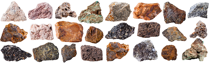
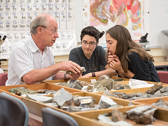
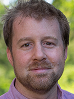
Geosciences professor John Brady has made a life’s work of deciphering the stories that rocks have to tell about the world, including the fascinating story of the landscape of the Connecticut River Valley—one that involves shifting continents, high mountains and a rift valley and that spans hundreds of millions of years.
In the uplands and lowlands of the Connecticut River Valley, rocks are everywhere, scattered through backyards and forests, among the lush gardens of the Smith College campus and the fields and forests of MacLeish Field Station. How these rocks got here is a fascinating story, an ancient one that involves shifting continents, high mountains and a rift valley—and that spans hundreds of millions of years. More recently, glaciers and erosion put finishing touches on the floodplains as well as the mountain ranges of the Connecticut Valley, the 19-town area surrounding Northampton and Amherst that is home to Smith and MacLeish.
“Every rock has a story,” John Brady, the Mary Elizabeth Moses Professor of Geosciences, likes to say.
And the collective story told by the assorted rocks in the Connecticut River Valley is dramatically punctuated by a geologic event 200 million years ago that included the movement of tectonic plates, the shaking of large earthquakes and the opening of an ocean basin as the land mass that is now Africa started to pull away from the North American continent.
John Brady
Brady is a hardrock geologist who studies the evolution of metamorphic rocks, particularly in Montana and Greece, and admits to already collecting “enough rocks for several lifetimes of research studies in the laboratory.” He says that the many rocks scattered throughout the 260 acres of the MacLeish Field Station in Whately, Massachusetts—whether they are in stone walls or boulders strewn about the hills—offer rich information about the continental glaciers that bulldozed their way across New England and the bedrock they scraped.
As part of the opening of the Atlantic Ocean, many rift valleys, which are fault-bounded lowlands between highlands or mountain ranges, formed on the edges of what became our current continents. One of these rift valleys is the geologic reason behind the existence of the Connecticut River Valley in western Massachusetts. Although the original rift valley was filled in with the red sandstone of Mount Sugarloaf, lava flows and other sediment, these soft rocks have since eroded to remake the lowland visible from MacLeish. The basalt lava flows are more resistant to erosion and hold up the ridges of Mount Holyoke and Mount Tom.
During the past 2 million years, several massive glacial ice sheets—the last one melting as recently as 16,000 years ago—covered and resurfaced the entire Connecticut Valley. Imagine two vertical miles of ice covering the landscape, ice that is solid but flowing south from Canada to its terminus at Long Island. When it melted, the glacier dropped the rocks, sand and silt that it had scraped from the surface as it moved. “The landscape is now draped with the droppings of that ice, what geologists call glacial till,” says Brady. Water from the melting ice filled the Connecticut Valley with a large body of water, named Lake Hitchcock after the Amherst College geologist and president who first recognized evidence of its existence. That evidence includes more than 1,000 (annual) layers of sand and clay sediment that covered the rocky glacial till and made the valley floor flat and very fertile for farming.
“There is no organization to the glacial till,” explains Brady. “If you dig a hole, you’re bound to find lots of clay, sand and pebbles, not to mention the giant rocks and boulders like those that litter the surface of the land. Some of those boulders came from Vermont, carried along by that thick stream of glacial ice.”
Through exploration of another kind—the deep geoscientific tracking and measuring of the still-moving tectonics of North America—the MacLeish Field Station reveals other, still-unfolding stories. It was designated in 2013 as a good site to install the EarthScope seismic station, through a Five College collaboration funded by the National Science Foundation.
The MacLeish station, EarthScope Station L61B, is one of hundreds of state-of-the-art seismometers installed in a national network across the United States. Like the others, this station continuously senses and records ground motions from a wide range of seismic sources, including local and distant earthquakes, volcanic eruptions, and other natural and human-induced activities in the local area. Daily readings of seismic activity can be viewed online.
The EarthScope Station “is helpful to geologists all over the country. One of the advantages of having a permanent research station like MacLeish,” says Brady, “is that data collection can take place here over a long period of time.”

The drive to the Ada and Archibald MacLeish Field Station in Whately, Massachusetts, 11 miles from the Smith campus, leads you down an old county road, first laid out through the dense forested land in the late 1700s. Back in the day, it was so well traveled that it became the major highway for early settlers traveling north from Whately to Conway, Massachusetts.
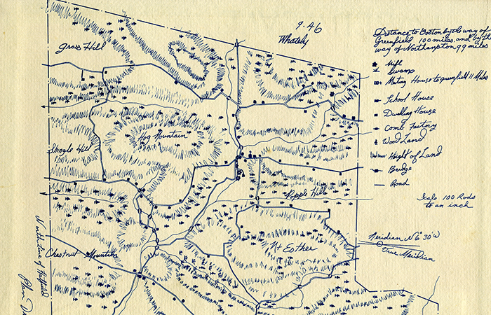
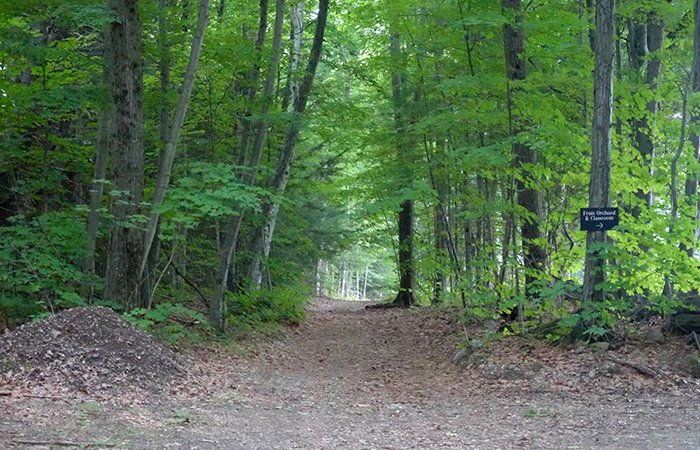
But today, there is nothing major about this quiet back road. It morphs and narrows from 20th-century asphalt to gravel and then to well-worn dirt and finally comes to a halt at a gate beneath the branches of towering 100-year-old trees, amidst one of the largest tracts of undeveloped land in Massachusetts.
Remarkably, the documented history of the 260 acres of MacLeish spans more than four centuries and is intricately woven with the stories of the humans who have walked the land dating back thousands of years—from the Native Americans who were drawn to the abundance and beauty of the area to the first Europeans who settled here in the early 1600s. Before the Europeans arrived, the Norwottuck peoples—considered part of the Nipmuc, Algonquin Native American tribes indigenous to central Massachusetts—planted cornfields and hunted in the thick forests.
By the mid-1600s, the first European settlers had “discovered” the naturally pristine and uncultivated land and taken ownership of specific tracts. As the new arrivals set up their homesteads, they cleared much of the woodlands in preparation for farming, mining and pasturing livestock, and within 100 years, the canopy of centuries-old trees of the original forested land had given way to open fields and cultivated farm lots.
Jesse Bellemare
According to a study by researchers with the Harvard University Harvard Forest and Jesse Bellemare, assistant professor of biological sciences at Smith College, the old-growth forest and a whole population of forest plant species were lost as the American agricultural economy flourished. The researchers, including lead author Bellemare, noted in a journal article, “Widespread agricultural land-use represents a novel disturbance in the naturally forested ecosystems of eastern North America with long-term impacts on plant community composition and structure.” The paper, “Legacies of the agricultural past in the forested present,” was published in the Journal of Biogeography in 2002
Ultimately, the uncultivated forested land went to “complete and rapid deforestation in a matter of years,” they wrote. “As in much of the Northeast, settlement initiated a period of rapid deforestation; nearly 80 percent of the landscape was cleared from the early 19th century through the late 19th century.”
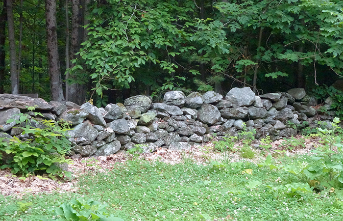
Stone walls, likely constructed during the heyday of sheep farming from 1800 to 1840, still dot the landscape at MacLeish, functioning as both pasture and crop field boundaries. Likewise, stone walls along the main path through MacLeish, an extension of Poplar Hill Road, define a well-traveled woodland path used to drive sheep in the 1800s.
So who owned the sheep, the cattle and the homesteads? And who stacked and engineered those complicated layers of rock to form those stone walls? Although the landscape of MacLeish has its own long narrative, further research delivers the names of some of those who have contributed to that story over the years.

Meredith Gallogly ’12
Meredith Gallogly ’12, as a Smith undergraduate, used an internship and a special studies project to delve into the history of property ownership of the MacLeish Field Station site. Among the many legal documents she consulted were the property deeds dating back for centuries and recorded at the Franklin County Registry of Deeds in Greenfield, Massachusetts.
Gallogly uncovered a medley of names, deeds and titles. Among those names was Asa Todd—a Baptist preacher who moved in 1791 to a Poplar Hill Road farm granted to him by the members of the church committee of the new Baptist meetinghouse he would lead.
Another name that surfaced—Oliver Smith—was linked to a tract of land that is now the location of the Bechtel environmental classroom at MacLeish. Smith started out in livestock and built a large fortune raising cattle on the pastureland where the classroom now sits. As it turns out, Oliver Smith was also an uncle to Sophia Smith, founder of Smith College, who lived in the neighboring town of Hatfield.
The Industrial Revolution again transformed the MacLeish landscape in the late 1800s. Farm fields were abandoned, and a secondary new forest emerged to reclaim old pastures, abandoned mines and farm lots.
The 21st-century forest we see today is quite different from the pristine 17th-century woodland that once blanketed the region, says Bellemare. Where sugar maples, hemlocks and beeches once provided a towering canopy over the forest floor, red maples, black birches and white pines are now the dominant trees.
It is the first wave of a new forest colonization that Bellemare and his students will continue to study in years to come, the land’s latest visitors who hope to leave less imprint than their predecessors.

The trail to the vernal pool would be hard to follow if it weren’t for markers nailed to the tree trunks. This Sunday morning in October, two Smith undergraduates and a professor are hiking along a forested path through the MacLeish Field Station, in search of surface water sources. Along the way, they stop to peer at remnants of abandoned 19th-century lead mines and the sizable chunks of quartz-mica schist discarded long ago in the mining process.
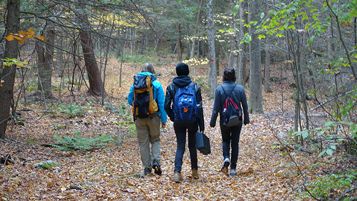
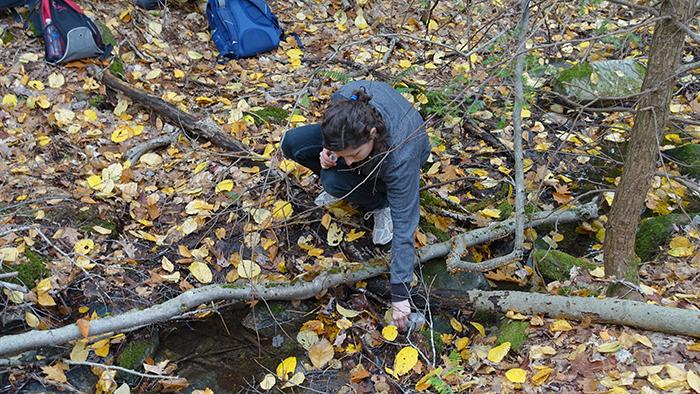
But what these three are really hoping to find is water. Amy Rhodes, associate professor of geosciences, leads the way. She’s been exploring this property for the past five or six years, using it as her environmental classroom and as the field site for several research projects, including one that analyzes the chemistry of the soil as a result of hemlock mortality. Now she is launching a new long-range project aimed at collecting water samples every few weeks from selected tributaries, ponds and other bodies of water scattered throughout the 260 acres of MacLeish.
Amy Rhodes
When they arrive at the site of the largest vernal pool on the western edge of the property, the pool is dry, as expected. Vernal pools, common in western Massachusetts, are depressions in the ground filled with water from snowmelt and rainfall in early spring, but by fall they have dried up and usually stay dry for the rest of the year. And this is October.
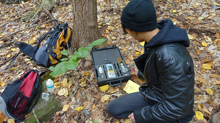
Earlier in the day, the group—Rhodes accompanied by Samantha Baierl ’18 and Zara Jamshed ’17— had crouched over a small stream just a few steps off the narrow, dirt Poplar Hill Road, which cuts through the MacLeish property. They were collecting surface water in small bottles; measuring the pH, dissolved oxygen and temperature; and recording the data in notebooks they carried in their backpacks. “We are checking to see how the water chemistry varies across the property,” Rhodes says, “and checking to see how bedrock chemistry may affect the water as well.”
Hemlock trees tower overhead and overgrown bushes ramble over this eastern tract of land, which in the early 1800s was plowed hayfields, cleared pastureland and apple orchards. Rhodes notes that arsenic was once used as a pesticide in fruit orchards in the late 19th century and may still show up in soil and water samples. “Basically we will be monitoring the quality of all the bodies of water on the property that have been affected by human activity.” [See related story about land-use history.]
But humans are not the only ones who have had an impact; invasive pests have also left a mark here, particularly on the composition of the forest—once thick with stands of native eastern hemlock trees. Those trees are stressed; some are dying. And the forest landscape is sure to change.
Jesse Bellemare
For several years, Rhodes and Jesse Bellemare, assistant professor of biological sciences, have been studying the effects of the hemlock woolly adelgid and hemlock scale insects in the forests at MacLeish, to better understand and predict how nutrient cycling and other ecosystem processes will change with the loss of the hemlocks throughout New England.
Working with Smith undergraduates in course projects and summer research, they are asking such questions as: What are the differences in the soil pH and nutrient cycling beneath hemlock and deciduous stands? What trees will grow in the gaps created by the anticipated hemlock die-off? And likewise, Will this changing forest affect common vertebrates like the red-backed salamanders and other forest-floor animal communities with the loss of the hemlocks and the subsequent changes in such factors as light levels, air temperatures and relative humidity?
Rhodes’ new water-sampling project builds on the ongoing soil study of terrestrial biodiversity at MacLeish that she has been conducting in forest plots there since 2010. She collects soil samples from pairs of forest plots, one that contains primarily the deciduous black birch and one that is primarily hemlock, and brings them back to the laboratory to be analyzed and processed. Hoping to collect a long-range data set for the MacLeish property, Rhodes is measuring rates of nitrogen production in the soil and looking at other nutrients relative to the chemistry of the soil and how it all varies between hemlock and younger black birch stands that succeeded hemlock in places logged 25 years ago. “The prior logging of hemlock and subsequent regrowth by black birch presented an ‘accidental experiment’ where we could see whether the forest soil ecosystem changed. From our measurements, we can anticipate possible future changes in the soil environment following infestation by hemlock wooly adelgid.”
This avenue of research was an unexpected but rewarding collaboration, says Rhodes. “MacLeish as a resource has sparked a productive interdisciplinary collaboration between the biological sciences and geosciences.”
Jenna Zukswert ’13
Indeed, the work has already resulted in several published papers. Among them was a paper published in 2014 in a special issue of the scholarly journal Southeastern Naturalist on hemlock research in the eastern United States. Lead author Jenna Zukswert ’13 was joined by co-authors and professors Bellemare and Rhodes, and four other Smith undergraduates. The paper—“Forest Community Structure Differs, but not Ecosystem Processes: 25 Years After Eastern Hemlock Removal in an Accidental Experiment”— documented how Smith researchers set out to collect baseline ecological data from forest stands at MacLeish.
Zukswert also produced a research poster of the same title, co-authored with professors Bellemare and Rhodes, for the Ecological Society of America’s annual meeting in 2013 and presented preliminary results at the American Geophysical Union meeting the previous year. The research showed significantly greater depth of the forest floor soil organic layer between the evergreen hemlocks and the deciduous, mostly black birch, tree stands at MacLeish, suggesting greater carbon storage in hemlock-dominated forests. Interestingly, soil geochemistry beneath the two forest types is similar after 25 years, although soil nitrogen concentrations increase over the short term while the hemlock trees die.
Without a doubt, the topic of New England’s changing forests is getting the attention it deserves. And more locally, at MacLeish, Rhodes says the field-based research opportunities for exploring those changes are rich. “MacLeish as a resource has caused me to pursue unique avenues of interdisciplinary research, and I am learning right alongside my students.”